2-day hike on the Grenairon mountain pasture - Stage 1

Hard
3h25min
6.53km
+1062m
2-day hike on the Grenairon mountain pasture - Stage 1 image1

Description

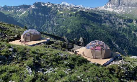
A short, sporty itinerary to the Grenairon refuge, formerly known as the Chalet Hôtel du Buet. Nestled at an altitude of 1974 metres, it offers magnificent views of the Fiz mountain range and the Anterne valley.

Marking

Departmental signposting on beige metal panels with green lettering.

Map references

TOP25 IGN - 3530ET - SAMOENS

Amenities

Itinerary
Guided steps

1/ From "La Feulatière (Parking)" head towards the Refuge de Grenairon via Les Crépines. Still following the signs for the Refuge de Grenairon, you will pass through "Les Fontaines (Parking)", "La Grande Joux" and "Les Crépines" before arriving at the Refuge de Grenairon.

Address
Parking de la Feulatière, Route des Fonds, 74740, Sixt-Fer-à-Cheval

Access (by car): From Cluses, join Taninges (D902), then the village of Samoëns via Morillon. From Samoëns, head for Sixt-Fer-à-Cheval (D902). In the village of Sixt-Fer-à-Cheval, turn right towards Salvagny (D29). Once in the hamlet of Salvagny, turn left onto route des Fonts to reach the La Feulatière parking lot.

Opening
From 15/06 to 30/09. Subject to favorable snow and weather conditions.

Subject to favorable weather, Subject to snow conditions

Was this content helpful to you?

Address
Parking de la Feulatière, Route des Fonds, 74740, Sixt-Fer-à-Cheval

Access (by car): From Cluses, join Taninges (D902), then the village of Samoëns via Morillon. From Samoëns, head for Sixt-Fer-à-Cheval (D902). In the village of Sixt-Fer-à-Cheval, turn right towards Salvagny (D29). Once in the hamlet of Salvagny, turn left onto route des Fonts to reach the La Feulatière parking lot.

Opening
From 15/06 to 30/09. Subject to favorable snow and weather conditions.

Subject to favorable weather, Subject to snow conditions